
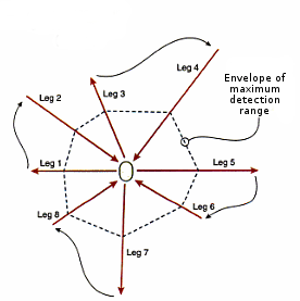
Conducting an AMDR test
A compass can also be helpful in navigating around the site.
Start by finding a location with vegetation and terrain typical of the search area.
- Place an object on the ground similar to that being sought, i.e. have a searcher in similar clothing lie down.
- Walk away from the object in a straight line, counting the number of paces travelled (leg #1). Look behind at regular intervals while moving until the object is no longer visible. Record the number of paces to that point. That is the detection range for that leg.
- Continue on the same path to ensure the next leg will start beyond the detection range, continuing to count paces. (The extra distance travelled will depend upon the local environment). Turn 90° and walk the same number of paces travelled to this point. This will put you at a 45° angle from the first leg.
- Walk toward the object (a compass may be useful here as the object should not be initially visible). As soon as the object becomes visible begin counting paces as you approach the object (leg #2). Record the number of paces for this leg.
- Turn onto a course 90° to leg #1 and walk away from the object. Repeat as step #2.
- Repeat the paces above for 8 legs, 45° apart. Retrieve the object upon completion.
Record the length of the 8 legs in the fields below, if you have created pacings in the Map section and one is suitable for the search area select it below and for each leg enter the paces and the paces will be converted to metres to determine the AMDR.